LIFEWATCH INDALO
Scientific infrastructure for monitoring biodiversity and its adaptation to global change in Andalusia
Project summary
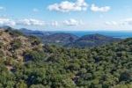
The INDALO project aims to study the biodiversity in different representative ecosystems of Andalusia, and to analyse their evolution to better understand the consequences of Global Change. Tools, equipment and networks monitoring, together with the necessary technology for the development of scientific tasks, will be made available to researchers in a common work environment so that managers and scientists can use and share information, favouring the transfer of the knowledge generated to relevant regional authorities to enhance biodiversity management measures. The INDALO infrastructure will act as an operational and integrating framework for scientific work including:
- The development of a Local Observatories Network in representative ecosystems of Andalusia as Thematic Centers of Reference, and
- Supporting the LifeWatch ERIC e-infrastructure in terms of standards and connections for the exchange of information and establishment of virtual laboratories and services.
INDALO’s main objectives are:
- To orient the future of Andalusian R&D&I in biodiversity and ecosystems towards the use of the LifeWatch infrastructure.
- To promote the science-administrative management linkage.
- To link the entire Andalusian environmental knowledge system to LifeWatch in a federated manner.
- To stimulate the connection of Andalusian R&D&I with the EU.
- To attract the private sector to innovate from LifeWatch.
Our role
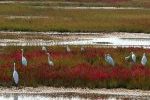
ETC-UMA is testing infrastructures and end-user friendly support tools to practicioners focusing on wetland management and protection.
Our work concerns the wetland monitoring system with remote sensing data involving the design and development of a monitoring tool, including:
- Delineation of Andalusian wetland areas building on their hydro-ecological boundaries.
- Design and develop a monitoring and assessment tool in near real time building on pre-identified and pre-defined indicators, to allow wetland managers and environmental administration bodies to calculate, visualize and extract relevant information on Andalusian wetlands.
Main outputs
More about it

Christoph Schröder
Project coordinationchristoph.schroder@uma.es
Based on my MSc in Geography (University of Bonn) I have developed expertise in Geographic Information Systems and land use/cover change analysis from local to global scale with particular interest in the Mediterranean...

Gabriel Martorell
Data and remote sensinggabrielmg@uma.es
Gabriel graduated in Geography at the University of the Balearic Islands. He has joined ETC-UMA as part of his master's degree in GIS and Remote Sensing, where he supports the collection, development and analysis of digital thematic cartography...Our partners
Agencia de Medio Ambiente y Agua de Andalucía (AMAYA)
Consejería de Universidad, Investigación e Innovación through the Agencia Andaluza del Conocimiento and LIFEWATCH Consortium (LIFEWATCH ERIC)
Instituto de Investigación y Formación Agraria y Pesquera de Andalucía, IFAPA
Instituto Nacional de Técnica Aeroespacial INTA
Universidad de Almería
Universidad de Cádiz
Universidad de Huelva
Universidad de Jaén
Universidad de Málaga
Universidad de Sevilla
Universidad Pablo de Olavide
POPE 2014-2020 operational program (FEDER) - LIFEWATCH ERIC line of action. Co-financed by Feder funds, the Ministry of Science and Innovation and the Ministry of Sustainable Development in Spain
GreenEye System: a cloud-based system to monitor wetlands in Andalusia
Looking back and forth to Mediterranean Forests

More space for innovative Mediterranean forest data partnerships
Job opening at the ETC-UMA: Senior Specialist in Nature Based Solutions for Climate Adaptation