SWOS - Satellite-based Wetlands Observation Service
A user-friendly wetland monitoring and information service developed with and for users
Project summary
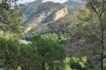
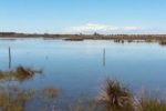
Despite the variety of crucial ecosystem services that wetlands provide, urbanisation, pollution and agricultural expansion are threatening their existence due to the lack of accurate Information on the location, extent and condition of the wetland ecosystem.
To set an appropriate ecological data system, the SWOS project developed a monitoring and information service for wetland ecosystems based on the European Space Agency’s Sentinel satellites. Deploying a wide set of technological innovations to improve wetland understanding and monitoring globally, the project focused on major policy frameworks such as Ramsar, CBD and EU nature directives, as well as considering local and national conservation and management objectives. The maps and tools developed in collaboration with data users aim to support reporting and monitoring obligations under various policy frameworks, with a more comprehensive hydroecological perception of wetlands.
Our role
Our contribution focused on the development of wetland mapping products and methodologies, policy orientation (particularly related to the EU MAES working group) and overall user engagement at local and national level. In this context, the team produced local case studies in Spain and Montenegro as well as for the MAES user community.
More specifically, the ETC-UMA team worked on:
- User engagement: Collection of user requirements and assessment of user feedback;
- Satellite data acquisition, pre-processing and mapping of different wetland sites;
- Organisation of training workshops at national and local level;
Support of and liaising with European and global policy initiatives (e.g. Ramsar, MAES working group).
Main outputs
Technical reports
SWOS modifications
Scientific publications
Sánchez, A. & Schröder, C. (2019)
Hatziiordano, L., Fitoka, E., Hadjicharalampous, E., Votsi, N., Palaskas, D., Abdul-Malak, D. (2019)
Spatial data
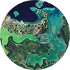
Contribution to mapping products for Laguna Fuente de Piedra & Lake Skadar, including Story Line on Fuente de Piedra
More about it

Dania Abdul Malak
Wetland-policy-related inquiriesdaniaabdulmalak@uma.es
Dania Abdul Malak is a senior environmental researcher and Director of the European Topic Centre at the University of Malaga (ETC-UMA). She has over 15 years’ experience in environmental assessment and management...

Antonio Sánchez
Remote-sensing and data related inquiriesa_sanchez@uma.es
Antonio Sánchez has developed his career focused on Geographic Information Systems and Remote Sensing tools, especially in the management and processing of data to calculate indicators and generate illustrative maps of environmental problems of all kind...Our partners
ETC-UMA launches new technologies applied to ecosystem knowledge