RHOMEO
Methodologies to monitor the Mediterranean basin of the Rhône River
Project summary
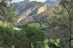
The RhoMeO project (Rhone Mediterranean Observatory), led by the Rhone Basin Water Authority, joins the efforts of managers and researchers to develop methodologies for the construction of an observatory to monitor the changing conditions of wetlands in the Mediterranean basin of the Rhône River.
The goal of the work of the ETC-UMA, in collaboration with Tour du Valat (TdV) is to assess the relevance of using new generation high-resolution (HR) satellite images as tools and to develop methods that can support detecting changes in wetlands at basin scale.
Our role
ETC-UMA developed 3 indicators based on remote sensing (SRS) and GIS to be used for wetland monitoring in the region Provence-Alpes-Côte d’Azur (PACA region), in southeastern France, for different dates between 1970 to 2012. Each indicator covers a particular aspect of these natural areas since the complexity of their operation requires different tools to assess their state at a given moment:
- Indicator 1: the total surface of wetlands at a given date.
- Indicator 2: the conversion of natural and semi-natural wetlands surface, between two dates, into either agriculture or urban areas.
- Indicator 3: the degree of flooding of wetlands over a year cycle.
Main outputs
Final Report
ETC-UMA contribution to the RhoMeo programme
Scientific Publication
Sánchez-Espinosa, A; Abdul-Malak, D; Guelmami, A; Perennou, C (2015)
More about it

Dania Abdul Malak
Wetland policy related inquiriesdaniaabdulmalak@uma.es
Dania Abdul Malak is a senior environmental researcher and Director of the European Topic Centre at the University of Malaga (ETC-UMA). She has over 15 years’ experience in environmental assessment and management...

Antonio Sánchez
Data related inquiriesa_sanchez@uma.es
Antonio Sánchez has developed his career focused on Geographic Information Systems and Remote Sensing tools, especially in the management and processing of data to calculate indicators and generate illustrative maps of environmental problems of all kind...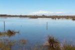
ETC-UMA launches new technologies applied to ecosystem knowledge