European Topic Centre on Urban, Land and Soil Systems (ETC/ULS)
Supporting urban, land and soil assessments on a European Scale to create seamless European wide information
Project summary
The ETC on Urban, Land and Soil Systems (ETC/ULS) is an international consortium working with the European Environment Agency (EEA) under a framework partnership agreement for the period 2019-2021. It supports the EEA in monitoring urban development in Europe, creating and managing seamless European-wide spatial reference data and developing and analysing various land and ecosystem-related indicators. ETC/ULS is a key player in different sectoral policies such as the EU Biodiversity Strategy, and the EU Roadmap to a Resource Efficient Europe among others.
The ETC/ULS is a follow-up of the European Topic Centres on Land Use and Spatial Information (LUSI) and Spatial Analysis and Information (SIA), which the University of Málaga joined in 2011.
Our role
Our team leads and participates in several key activities of the ETC/ULS, providing technical and thematic expertise, particularly related to:
- Development of the Integrated Data Platform.
- Support to the EEA ecosystem accounting with land, water and nutrient accounts.
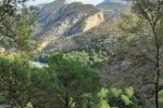
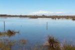
- Participation in the European ecosystem assessments in the context of the Working Group on Mapping and Assessment of Ecosystem and their Services, with specific focus on wetland and forest ecosystems.
- Coordination of forest indicator development and forest assessments.
- Development of assessments of soil conditions.
Main outputs
Technical reports
Ivits et al. (2020). ETC/ULS Report 02/2020
Maes et al. (2020). Publications Office of the European Union
Gregor, M; Löhnertz, M; Schröder, C; Aksoy, E; Prokop, G; Louwagie, G (2018). ETC/ULS Report 02/2018
Scientific publications
Aksoy, E; Louwagie, G; Gardi, C; Gregor, M; Schröder, C; Löhnertz, M (2017)
Aksoy, E; Gregor, M; Schröder, C; Löhnertz, M; Louwagie, G. (2017)
Spatial data

Geospatial data catalogue of the European Enviroment Agency
More about it

Emanuele Mancosu
Data managementemanuele.mancosu@uma.es
Strong interests and curiosity about environment subjects and informatics technology. The academic career was orientated in natural science finished in 2004 with highest honors with particular attention on GIS...
Dania Abdul Malak
Wetland policy related inquiriesdaniaabdulmalak@uma.es
Dania Abdul Malak is a senior environmental researcher and Director of the European Topic Centre at the University of Malaga (ETC-UMA). She has over 15 years’ experience in environmental assessment and management...
Our partners
European Environment Agency
ETC-UMA launches new technologies applied to ecosystem knowledge